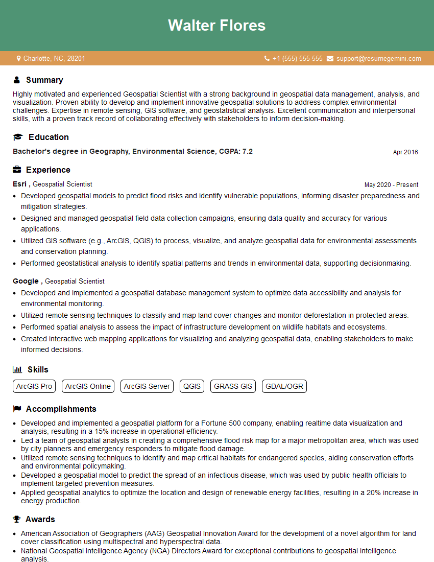
Are you a seasoned Geospatial Scientist seeking a new career path? Discover our professionally built Geospatial Scientist Resume Template. This time-saving tool provides a solid foundation for your job search. Simply click “Edit Resume” to customize it with your unique experiences and achievements. Customize fonts and colors to match your personal style and increase your chances of landing your dream job. Explore more Resume Templates for additional options.

Walter Flores
Geospatial Scientist
Summary
Highly motivated and experienced Geospatial Scientist with a strong background in geospatial data management, analysis, and visualization. Proven ability to develop and implement innovative geospatial solutions to address complex environmental challenges. Expertise in remote sensing, GIS software, and geostatistical analysis. Excellent communication and interpersonal skills, with a proven track record of collaborating effectively with stakeholders to inform decision-making.
Education
Bachelor’s degree in Geography, Environmental Science
April 2016
Skills
- ArcGIS Pro
- ArcGIS Online
- ArcGIS Server
- QGIS
- GRASS GIS
- GDAL/OGR
Work Experience
Geospatial Scientist
- Developed geospatial models to predict flood risks and identify vulnerable populations, informing disaster preparedness and mitigation strategies.
- Designed and managed geospatial field data collection campaigns, ensuring data quality and accuracy for various applications.
- Utilized GIS software (e.g., ArcGIS, QGIS) to process, visualize, and analyze geospatial data for environmental assessments and conservation planning.
- Performed geostatistical analysis to identify spatial patterns and trends in environmental data, supporting decisionmaking.
Geospatial Scientist
- Developed and implemented a geospatial database management system to optimize data accessibility and analysis for environmental monitoring.
- Utilized remote sensing techniques to classify and map land cover changes and monitor deforestation in protected areas.
- Performed spatial analysis to assess the impact of infrastructure development on wildlife habitats and ecosystems.
- Created interactive web mapping applications for visualizing and analyzing geospatial data, enabling stakeholders to make informed decisions.
Accomplishments
- Developed and implemented a geospatial platform for a Fortune 500 company, enabling realtime data visualization and analysis, resulting in a 15% increase in operational efficiency.
- Led a team of geospatial analysts in creating a comprehensive flood risk map for a major metropolitan area, which was used by city planners and emergency responders to mitigate flood damage.
- Utilized remote sensing techniques to identify and map critical habitats for endangered species, aiding conservation efforts and environmental policymaking.
- Developed a geospatial model to predict the spread of an infectious disease, which was used by public health officials to implement targeted prevention measures.
- Applied geospatial analytics to optimize the location and design of renewable energy facilities, resulting in a 20% increase in energy production.
Awards
- American Association of Geographers (AAG) Geospatial Innovation Award for the development of a novel algorithm for land cover classification using multispectral and hyperspectral data.
- National Geospatial Intelligence Agency (NGA) Directors Award for exceptional contributions to geospatial intelligence analysis.
- Presidents Council of Advisors on Science and Technology (PCAST) Honorable Mention Award for a research project on the use of geospatial data to improve disaster response.
- International Society for Photogrammetry and Remote Sensing (ISPRS) Young Scientist Award for a research project on the application of machine learning to geospatial data.
Certificates
- Certified ArcGIS Professional (CAP)
- Esri Certified Desktop Associate
- Esri Certified Enterprise Architect
- Google Earth Engine Certified Professional
Career Expert Tips:
- Select the ideal resume template to showcase your professional experience effectively.
- Master the art of resume writing to highlight your unique qualifications and achievements.
- Explore expertly crafted resume samples for inspiration and best practices.
- Build your best resume for free this new year with ResumeGemini. Enjoy exclusive discounts on ATS optimized resume templates.
How To Write Resume For Geospatial Scientist
- Highlight your technical skills and expertise in geospatial technologies, including GIS software, remote sensing, and geostatistical analysis.
- Showcase your ability to apply geospatial principles to solve real-world problems in environmental management, conservation, or other relevant fields.
- Demonstrate your strong analytical and problem-solving skills, as well as your ability to communicate complex geospatial information effectively.
- Emphasize your experience in developing and implementing geospatial solutions that have had a positive impact on environmental decision-making.
Essential Experience Highlights for a Strong Geospatial Scientist Resume
- Developed and implemented a geospatial database management system to optimize data accessibility and analysis for environmental monitoring.
- Utilized remote sensing techniques to classify and map land cover changes and monitor deforestation in protected areas.
- Performed spatial analysis to assess the impact of infrastructure development on wildlife habitats and ecosystems.
- Created interactive web mapping applications for visualizing and analyzing geospatial data, enabling stakeholders to make informed decisions.
- Developed geospatial models to predict flood risks and identify vulnerable populations, informing disaster preparedness and mitigation strategies.
Frequently Asked Questions (FAQ’s) For Geospatial Scientist
What are the key skills required to be a successful Geospatial Scientist?
Key skills include proficiency in GIS software, remote sensing techniques, geostatistical analysis, data management, and communication.
What industries hire Geospatial Scientists?
Geospatial Scientists are employed in various industries, including environmental consulting, natural resource management, urban planning, and disaster management.
What is the career outlook for Geospatial Scientists?
The job outlook for Geospatial Scientists is expected to grow faster than average due to the increasing demand for geospatial data and analysis.
What are the typical educational requirements for Geospatial Scientists?
Most Geospatial Scientists hold a bachelor’s or master’s degree in geography, environmental science, or a related field.
What are the key responsibilities of a Geospatial Scientist?
Responsibilities include collecting, managing, analyzing, and visualizing geospatial data to solve environmental problems and inform decision-making.