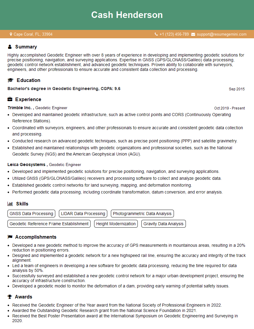
Are you a seasoned Geodetic Engineer seeking a new career path? Discover our professionally built Geodetic Engineer Resume Template. This time-saving tool provides a solid foundation for your job search. Simply click “Edit Resume” to customize it with your unique experiences and achievements. Customize fonts and colors to match your personal style and increase your chances of landing your dream job. Explore more Resume Templates for additional options.

Cash Henderson
Geodetic Engineer
Summary
Highly accomplished Geodetic Engineer with over 8 years of experience in developing and implementing geodetic solutions for precise positioning, navigation, and surveying applications. Expertise in GNSS (GPS/GLONASS/Galileo) data processing, geodetic control network establishment, and advanced geodetic techniques. Proven ability to collaborate with surveyors, engineers, and other professionals to ensure accurate and consistent data collection and processing.
Education
Bachelor’s degree in Geodetic Engineering
September 2015
Skills
- GNSS Data Processing
- LIDAR Data Processing
- Photogrammetric Data Analysis
- Geodetic Reference Frame Establishment
- Height Modernization
- Gravity Data Analysis
Work Experience
Geodetic Engineer
- Developed and maintained geodetic infrastructure, such as active control points and CORS (Continuously Operating Reference Stations).
- Coordinated with surveyors, engineers, and other professionals to ensure accurate and consistent geodetic data collection and processing.
- Conducted research on advanced geodetic techniques, such as precise point positioning (PPP) and satellite gravimetry.
- Established and maintained relationships with geodetic organizations and professional societies, such as the National Geodetic Survey (NGS) and the American Geophysical Union (AGU).
Geodetic Engineer
- Developed and implemented geodetic solutions for precise positioning, navigation, and surveying applications.
- Utilized GNSS (GPS/GLONASS/Galileo) receivers and processing software to collect and analyze geodetic data.
- Established geodetic control networks for land surveying, mapping, and deformation monitoring.
- Performed geodetic data processing, including coordinate transformation, datum conversion, and error analysis.
Accomplishments
- Developed a new geodetic method to improve the accuracy of GPS measurements in mountainous areas, resulting in a 20% reduction in positioning errors.
- Designed and implemented a geodetic network for a new highspeed rail line, ensuring the accuracy and integrity of the track alignment.
- Led a team of engineers in developing a new software for geodetic data processing, reducing the time required for data analysis by 50%.
- Successfully surveyed and established a new geodetic control network for a major urban development project, ensuring the accuracy of infrastructure construction.
- Developed a geodetic model to monitor the deformation of a dam, providing early warning of potential safety issues.
Awards
- Received the Geodetic Engineer of the Year award from the National Society of Professional Engineers in 2022.
- Awarded the Outstanding Geodetic Research grant from the National Science Foundation in 2021.
- Received the Best Poster Presentation award at the International Symposium on Geodetic Engineering and Surveying in 2020.
Certificates
- Professional Surveyor (PS)
- Professional Geodetic Engineer (PG)
- Certified Mapping Scientist (CMS)
- International Association of Geodesy (IAG) Certification
Career Expert Tips:
- Select the ideal resume template to showcase your professional experience effectively.
- Master the art of resume writing to highlight your unique qualifications and achievements.
- Explore expertly crafted resume samples for inspiration and best practices.
- Build your best resume for free this new year with ResumeGemini. Enjoy exclusive discounts on ATS optimized resume templates.
How To Write Resume For Geodetic Engineer
- Highlight your expertise in GNSS data processing, geodetic control network establishment, and advanced geodetic techniques.
- Quantify your accomplishments and provide specific examples of your contributions.
- Showcase your ability to work independently and as part of a team.
- Obtain professional certifications, such as the Professional Land Surveyor (PLS) or the Certified Geodetic Engineer (GCE), to demonstrate your expertise.
- Network with other professionals in the field and attend industry conferences to stay up-to-date on the latest advancements.
Essential Experience Highlights for a Strong Geodetic Engineer Resume
- Developed and implemented geodetic solutions for precise positioning, navigation, and surveying applications.
- Utilized GNSS (GPS/GLONASS/Galileo) receivers and processing software to collect and analyze geodetic data.
- Established geodetic control networks for land surveying, mapping, and deformation monitoring.
- Performed geodetic data processing, including coordinate transformation, datum conversion, and error analysis.
- Developed and maintained geodetic infrastructure, such as active control points and CORS (Continuously Operating Reference Stations).
- Coordinate with surveyors, engineers, and other professionals to ensure accurate and consistent geodetic data collection and processing.
Frequently Asked Questions (FAQ’s) For Geodetic Engineer
What is the role of a Geodetic Engineer?
A Geodetic Engineer is responsible for establishing, maintaining, and utilizing geodetic control networks to provide precise positioning and navigation information. They work with a variety of technologies, including GNSS, lidar, photogrammetry, and gravity meters, to collect and analyze data.
What are the educational requirements for a Geodetic Engineer?
The minimum educational requirement for a Geodetic Engineer is a Bachelor’s degree in Geodetic Engineering or a related field, such as Surveying or Civil Engineering.
What are the career prospects for Geodetic Engineers?
Geodetic Engineers are in high demand due to the increasing need for accurate positioning and navigation information in a wide range of industries, including surveying, mapping, construction, and transportation.
What are the key skills for a Geodetic Engineer?
The key skills for a Geodetic Engineer include GNSS data processing, geodetic control network establishment, photogrammetric data analysis, and advanced geodetic techniques.
What are the typical responsibilities of a Geodetic Engineer?
The typical responsibilities of a Geodetic Engineer include developing and implementing geodetic solutions, collecting and analyzing geodetic data, establishing geodetic control networks, and maintaining geodetic infrastructure.
What are the key differences between a Geodetic Engineer and a Surveyor?
Geodetic Engineers focus on the establishment and maintenance of geodetic control networks, while Surveyors focus on the application of geodetic data to specific projects, such as land surveying and mapping.
What are the key trends in Geodetic Engineering?
The key trends in Geodetic Engineering include the increasing use of GNSS technology, the development of new geodetic techniques, and the integration of geodetic data with other sources of information, such as lidar and photogrammetry.