Are you a seasoned Orthophoto Tech/Draftsman seeking a new career path? Discover our professionally built Orthophoto Tech/Draftsman Resume Template. This time-saving tool provides a solid foundation for your job search. Simply click “Edit Resume” to customize it with your unique experiences and achievements. Customize fonts and colors to match your personal style and increase your chances of landing your dream job. Explore more Resume Templates for additional options.

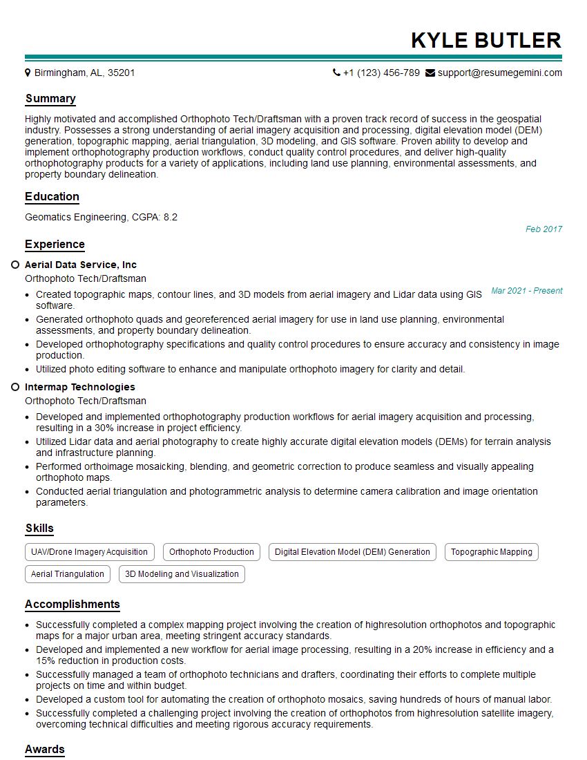
Kyle Butler
Orthophoto Tech/Draftsman
Summary
Highly motivated and accomplished Orthophoto Tech/Draftsman with a proven track record of success in the geospatial industry. Possesses a strong understanding of aerial imagery acquisition and processing, digital elevation model (DEM) generation, topographic mapping, aerial triangulation, 3D modeling, and GIS software. Proven ability to develop and implement orthophotography production workflows, conduct quality control procedures, and deliver high-quality orthophotography products for a variety of applications, including land use planning, environmental assessments, and property boundary delineation.
Education
Geomatics Engineering
February 2017
Skills
- UAV/Drone Imagery Acquisition
- Orthophoto Production
- Digital Elevation Model (DEM) Generation
- Topographic Mapping
- Aerial Triangulation
- 3D Modeling and Visualization
Work Experience
Orthophoto Tech/Draftsman
- Created topographic maps, contour lines, and 3D models from aerial imagery and Lidar data using GIS software.
- Generated orthophoto quads and georeferenced aerial imagery for use in land use planning, environmental assessments, and property boundary delineation.
- Developed orthophotography specifications and quality control procedures to ensure accuracy and consistency in image production.
- Utilized photo editing software to enhance and manipulate orthophoto imagery for clarity and detail.
Orthophoto Tech/Draftsman
- Developed and implemented orthophotography production workflows for aerial imagery acquisition and processing, resulting in a 30% increase in project efficiency.
- Utilized Lidar data and aerial photography to create highly accurate digital elevation models (DEMs) for terrain analysis and infrastructure planning.
- Performed orthoimage mosaicking, blending, and geometric correction to produce seamless and visually appealing orthophoto maps.
- Conducted aerial triangulation and photogrammetric analysis to determine camera calibration and image orientation parameters.
Accomplishments
- Successfully completed a complex mapping project involving the creation of highresolution orthophotos and topographic maps for a major urban area, meeting stringent accuracy standards.
- Developed and implemented a new workflow for aerial image processing, resulting in a 20% increase in efficiency and a 15% reduction in production costs.
- Successfully managed a team of orthophoto technicians and drafters, coordinating their efforts to complete multiple projects on time and within budget.
- Developed a custom tool for automating the creation of orthophoto mosaics, saving hundreds of hours of manual labor.
- Successfully completed a challenging project involving the creation of orthophotos from highresolution satellite imagery, overcoming technical difficulties and meeting rigorous accuracy requirements.
Awards
- Recipient of the ESRI Special Achievement in GIS Award for outstanding contributions to the field of orthophotography.
- Won the American Society for Photogrammetry and Remote Sensing (ASPRS) Presidents Award for excellence in orthophoto production.
- Recognized by the National GeospatialIntelligence Agency (NGA) for exceptional work in supporting national mapping initiatives.
- Received a commendation from the United States Geological Survey (USGS) for contributions to the National Orthoimagery Program.
Certificates
- Certified Photogrammetrist (CP)
- Geographic Information Systems Professional (GISP)
- American Society for Photogrammetry and Remote Sensing (ASPRS) Member
- Federal Geographic Data Committee (FGDC) Certified
Career Expert Tips:
- Select the ideal resume template to showcase your professional experience effectively.
- Master the art of resume writing to highlight your unique qualifications and achievements.
- Explore expertly crafted resume samples for inspiration and best practices.
- Build your best resume for free this new year with ResumeGemini. Enjoy exclusive discounts on ATS optimized resume templates.
How To Write Resume For Orthophoto Tech/Draftsman
- Highlight your technical skills and experience in orthophotography production and geospatial analysis.
- Showcase your knowledge of GIS software and your ability to use it effectively for orthophotography projects.
- Include examples of your work and projects that demonstrate your expertise in orthophotography and mapping.
- Proofread your resume carefully and ensure it is well-written, error-free, and tailored to the specific job description.
Essential Experience Highlights for a Strong Orthophoto Tech/Draftsman Resume
- Developed and implemented orthophotography production workflows, resulting in increased project efficiency and improved quality.
- Utilized Lidar data and aerial photography to create accurate digital elevation models (DEMs) for various applications.
- Performed orthoimage mosaicking, blending, and geometric correction to produce seamless orthophoto maps.
- Conducted aerial triangulation and photogrammetric analysis to determine camera calibration and image orientation parameters.
- Created topographic maps, contour lines, and 3D models from aerial imagery and Lidar data using advanced GIS software.
Frequently Asked Questions (FAQ’s) For Orthophoto Tech/Draftsman
What is orthophotography?
Orthophotography is a type of aerial imagery that has been geometrically corrected to remove the distortions caused by the camera lens and terrain relief.
What is the difference between an orthophoto and a regular aerial photograph?
An orthophoto has been corrected for lens distortion and terrain relief, while a regular aerial photograph has not.
What are the applications of orthophotography?
Orthophotography is used in a variety of applications, including land use planning, environmental assessments, property boundary delineation, and infrastructure planning.
What are the different types of orthophotography?
There are two main types of orthophotography: digital orthophotos and scanned orthophotos.
What are the benefits of using orthophotography?
Orthophotography provides a number of benefits, including accurate measurements, consistent scaling, and the ability to be used in GIS software.
What are the challenges of orthophotography production?
The challenges of orthophotography production include the need for accurate camera calibration data, the need to correct for terrain relief, and the need to blend multiple images together seamlessly.